Showing 53 items matching quartz reef mining
-
 Stawell Historical Society Inc
Archive, Pleasant Creek Cross Reef Quartz Mining Co, 1864
... Pleasant Creek Cross Reef Quartz Mining Co.... grampians Archive Pleasant Creek Cross Reef Quartz Mining Co ...Burgundy Covered Book. Register of Share Holdersstawell, mining -
Federation University Historical Collection
Booklet, Wendy Morris, A Guide to Maldon, 1983
... quartz reef mining... maldon mining streetscape townscape gardens quartz reef mining ...Soft covered booklet featuring an aerial view of the town of Maldon on the cover. heritage, tourism, maldon, mining, streetscape, townscape, gardens, quartz reef mining, geology, maldon goldmines, maldon hospital, kangaroo hotel, architecture, conservation and planning, cast iron, forests, mount tarrangower, nuggetty ranges, beehive -
Marysville & District Historical Society
Booklet (item) - Information booklet, Artworkz Tourism, Gold & Mining, Unknown
... quartz reef mining... alluvial mining quartz reef mining walhalla quartz reef mine mount ...A booklet that was produced of information regarding gold and gold mining in Australia.A booklet that was produced of information regarding gold and gold mining in Australia.gold, gold mining, californian gold rush, australian gold rush, new south wales gold rush, victorian gold rush, eureka stockade, redgate diggings, eglington mine, redgate, alexandra, alluvial mining, quartz reef mining, walhalla quartz reef mine, mount pleasant diggings, artworks tourism -
 Marysville & District Historical Society
Photograph (item) - Black and white photograph, Unknown
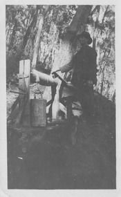
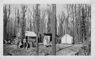
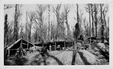
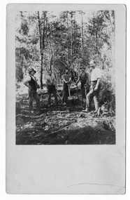
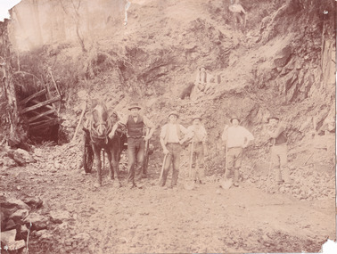
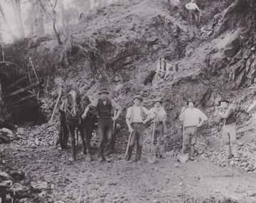
... quartz reef mining.... The Golden Bower gold mine was a quartz reef mine. William Edward ...An early black and white photograph taken at the Golden Bower in the Cumberland Valley in Victoria.An early black and white photograph taken at the Golden Bower Mine in the Cumberland Valley in Victoria. The Golden Bower gold mine was a quartz reef mine. William Edward Chester discovered the Golden Secret gold vein which became part of the Golden Bower Mine at Chesterville near Donovans Creek on the Cumberland goldfield which he mined with George Locke until the late 1930s. golden bower gold mine, cumberland valley, victoria, quartz reef mining, water-powered battery, william edward chester, george locke, chesterville, donovan's creek, cumberland goldfield -
 Marysville & District Historical Society
Photograph (item) - Black and white photograph, Unknown
... quartz reef mining... Bower gold mine was a quartz reef mine. William Edward Chester ...An early black and white photograph of the blacksmith's forge at the Golden Bower mine in the Cumberland Valley in Victoria.An early black and white photograph taken at the Golden Bower Mine in the Cumberland Valley in Victoria. The Golden Bower gold mine was a quartz reef mine. William Edward Chester discovered the Golden Secret gold vein which became part of the Golden Bower Mine at Chesterville near Donovans Creek on the Cumberland goldfield which he mined with George Locke until the late 1930s. golden bower gold mine, cumberland valley, victoria, quartz reef mining, water-powered battery, william edward chester, george locke, chesterville, donovan's creek, cumberland goldfield -
 Marysville & District Historical Society
Photograph (item) - Black and white photograph, Unknown
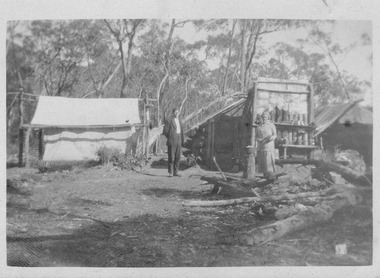
... quartz reef mining... cumberland valley victoria quartz reef mining water-powered battery ...An early black and white photograph of the Golden Bower mine in the Cumberland Valley in Victoria.An early black and white photograph taken at the Golden Bower Mine in the Cumberland Valley in Victoria. The Golden Bower gold mine was a quartz reef mine. William Edward Chester discovered the Golden Secret gold vein which became part of the Golden Bower Mine at Chesterville near Donovans Creek on the Cumberland goldfield which he mined with George Locke until the late 1930s. golden bower gold mine, cumberland valley, victoria, quartz reef mining, water-powered battery, william edward chester, george locke, chesterville, donovan's creek, cumberland goldfield -
 Marysville & District Historical Society
Photograph (item) - Black and white photograph, Unknown
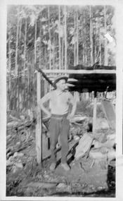
... quartz reef mining... cumberland valley victoria quartz reef mining water-powered battery ...An early black and white photograph of the Golden Bower mine camp in the Cumberland Valley in Victoria.An early black and white photograph taken at the Golden Bower Mine in the Cumberland Valley in Victoria. The Golden Bower gold mine was a quartz reef mine. William Edward Chester discovered the Golden Secret gold vein which became part of the Golden Bower Mine at Chesterville near Donovans Creek on the Cumberland goldfield which he mined with George Locke until the late 1930s. golden bower gold mine, cumberland valley, victoria, quartz reef mining, water-powered battery, william edward chester, george locke, chesterville, donovan's creek, cumberland goldfield -
 Marysville & District Historical Society
Photograph (item) - Black and white photograph, Unknown
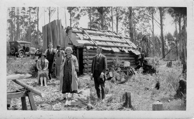
... quartz reef mining... mine cumberland valley victoria quartz reef mining water ...An early black and white photograph taken at the Golden Bower Mine Camp in the Cumberland Valley in Victoria.An early black and white photograph taken at the Golden Bower Mine in the Cumberland Valley in Victoria. The Golden Bower gold mine was a quartz reef mine. William Edward Chester discovered the Golden Secret gold vein which became part of the Golden Bower Mine at Chesterville near Donovans Creek on the Cumberland goldfield which he mined with George Locke until the late 1930s. golden bower gold mine, cumberland valley, victoria, quartz reef mining, water-powered battery, william edward chester, george locke, chesterville, donovan's creek, cumberland goldfield -
 Marysville & District Historical Society
Photograph (item) - Black and white photograph, Unknown
... quartz reef mining... cumberland valley victoria quartz reef mining water-powered battery ...An early black and white photograph taken at the Golden Bower Mine in the Cumberland Valley in Victoria.An early black and white photograph taken at the Golden Bower Mine in the Cumberland Valley in Victoria. The Golden Bower gold mine was a quartz reef mine. William Edward Chester discovered the Golden Secret gold vein which became part of the Golden Bower Mine at Chesterville near Donovans Creek on the Cumberland goldfield which he mined with George Locke until the late 1930s. golden bower gold mine, cumberland valley, victoria, quartz reef mining, water-powered battery, william edward chester, george locke, chesterville, donovan's creek, cumberland goldfield -
 Marysville & District Historical Society
Postcard (item) - Black and white postcard, Unknown
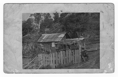
... quartz reef mining... mine cumberland valley victoria quartz reef mining water ...An early black and white photograph taken at the Golden Bower Mine in the Cumberland Valley in Victoria.An early black and white photograph taken at the Golden Bower Mine in the Cumberland Valley in Victoria. The Golden Bower gold mine was a quartz reef mine. William Edward Chester discovered the Golden Secret gold vein which became part of the Golden Bower Mine at Chesterville near Donovans Creek on the Cumberland goldfield which he mined with George Locke until the late 1930s. POST CARD EMPIRE FOR CORRESPONDENCE FOR ADDRESS ONLY STAMPgolden bower gold mine, cumberland valley, victoria, quartz reef mining, water-powered battery, william edward chester, george locke, chesterville, donovan's creek, cumberland goldfield, postcard, souvenir -
 Marysville & District Historical Society
Postcard (item) - Black and white postcard, Unknown
... quartz reef mining.... The Golden Bower gold mine was a quartz reef mine. William Edward ...An early black and white photograph taken at the Golden Bower Mine Camp in the Cumberland Valley in Victoria.An early black and white photograph taken at the Golden Bower Mine Camp in the Cumberland Valley in Victoria. The Golden Bower gold mine was a quartz reef mine. William Edward Chester discovered the Golden Secret gold vein which became part of the Golden Bower Mine at Chesterville near Donovans Creek on the Cumberland goldfield which he mined with George Locke until the late 1930s. POST CARD CORRESPONDENCE. ADDRESS ONLY. KODAK/ AUSTRALIA 30/06/10 Rose Hill/ Fitzwilliam Street/ Kew Should have written/ to you months ago about the/ photos I took at Easter./ Sorry to say the one of the little/ girls was no good I expect/ you will recognise both these/ places/ K McDowell Mrs Fletcher/ Golden Bower Mine/ Via Marysville J Mahoneygolden bower gold mine, cumberland valley, victoria, quartz reef mining, water-powered battery, william edward chester, george locke, chesterville, donovan's creek, cumberland goldfield -
 The Beechworth Burke Museum
Photograph
... mining, or quartz reef mining, was common in 19th Century.... Reef mining, or quartz reef mining, was common in 19th Century ...This photograph depicts a reef mine in Beechworth. Reef mining, or quartz reef mining, was common in 19th Century Victoria. This gold mining technique requires mine shafts to be sunk into underground quartz reefs, with horizontal tunnels dug from the original shaft at differing levels to find the gold-bearing rock. The quartz would then be hoisted to the surface, which would then be pounded to access the gold in its metallic state. Gold was discovered in Beechworth in February 1852, at Spring Creek. Within 11 months of that discovery, over 8000 hopeful prospectors quickly descended on this region, transforming it into a thriving, wealthy township. Reef mining and hydraulic sluicing were gold mining techniques used in this region in the 19th and early 20th centuries. This photograph interestingly contains dogs alongside the miners. While dogs have been recorded as deterrents to thieves in the Victorian goldfields, these dogs appear as companions to these men.The search for gold is ingrained into the history of Victoria and therefore, images like this one can reveal important information for society and technology for the date when the photograph was taken. It also shows a location where reef mining was undertaken which provides insight into the impact on the environment at a time when it was done. Although quartz is one of the most common minerals found in the earth's crust, it does not always contain gold. Those reefs that do are rare and highly sought after by prospectors. The Beechworth Burke Museum has additional images relating to gold mining which can be analysed and studied alongside images like this one.Sepia coloured rectangular photograph printed on gloss photographic paper. Obverse: Reverse: United Shire of Beechworth/ Shire Secretary/ Reef Mining, Beechworth./ 6167.abeechworth, burke museum, gold, gold mining, gold rush, victorian gold rush, reef mining, quartz, companion dog, horse and cart -
 The Beechworth Burke Museum
Photograph - Photograph - Reproduction
... in Beechworth. Reef mining, or quartz reef mining, was common in 19th... photograph depicts a reef mine in Beechworth. Reef mining, or quartz ...This reproduced photograph depicts a reef mine in Beechworth. Reef mining, or quartz reef mining, was common in 19th Century Victoria. This gold mining technique requires mine shafts to be sunk into underground quartz reefs, with horizontal tunnels dug from the original shaft at differing levels to find the gold-bearing rock. The quartz would then be hoisted to the surface, which would then be pounded to access the gold in its metallic state. Gold was discovered in Beechworth in February 1852, at Spring Creek. 8000 hopeful prospectors quickly descended on this region within the year, transforming it into a thriving, wealthy township. Reef mining and hydraulic sluicing were gold mining techniques used in this region in the 19th and early 20th centuries. This reproduction photograph interestingly contains dogs alongside the miners. While dogs have been recorded as deterrents to thieves in the Victorian goldfields, these dogs appear as companions to these men.The search for gold is ingrained into the history of Victoria and therefore, images like this one can reveal important information for society and technology for the date when the photograph was taken. It also shows a location where reef mining was undertaken which provides insight into the impact on the environment at a time when it was done. The Beechworth Burke Museum has additional images relating to gold mining which can be analysed and studied alongside images like this one.Black and white rectangular reproduction photograph on gloss photographic paper. Obverse: Reverse: L is miners 26%/ 10 x 8/ 6167.bbeechworth, burke museum, gold, gold mining, gold rush, victorian gold rush, reef mining, quartz, companion dog, horse and cart -
 Ballarat Heritage Services
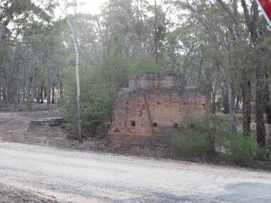
Photograph - Photograph - Colour, Steele's Pioneer Mine Ruins, Yandoit, 2016, 18/01/2016
... mining parties until the late 1880s. In 1887, the Steele's Reef.... In 1887, the Steele's Reef Quartz Mining Company fixed steam ...Steele's Reef was opened in 1859 along with a number of other reefs in the Yandoit area. The reef was worked by small mining parties until the late 1880s. In 1887, the Steele's Reef Quartz Mining Company fixed steam pumping machinery and commenced sinking a shaft. The company were unable to find a profitable ore body and after two years work closed down. By this time their shaft had reached a depth of 150 feet. The mine was then taken over by the Pioneer Quartz Mining Company who appear not to have worked the mine. In 1906, the Steele's Pioneer Company commenced work, erecting a winding winch at the old shaft sunk by the Steele's Company. The next year the company erected a 10-head battery, set of poppet legs, a pumping engine. Sinking the shaft a further 100 feet, the company struggled to find payable ore and soon closed down.Colour photographs of the remnants of Steele's mine at Yandoit, Victoria. steele's mine, yandoit, mining, ruins -
 Kew Historical Society Inc
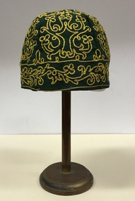
Headwear - Green Cotton & Yellow Silk Ribbon Smoker's or Lounge Cap, 1860s
... Quartz Mining Company, which had built the largest water wheel... Middleton’s Reef Gold Quartz Mining Company, which had built ...The context in which the hat was made and worn assists in establishing its potential historic significance. 'Bailliere's Victorian Gazetteer and Road Guide containing the most recent and accurate information as to every place in the Colony' (1870), describes the village of Vaughan as being located on the road from Daylesford to Castlemaine. In 1870 the Vaughan was deemed to be entirely a gold mining area, gold having been discovered in the district in 1853. Intriguingly the entry in the Gazetteer claims that the electoral division of Vaughan began at the junction of the Middleton Creek and the Loddon River, so perhaps the cap might have belonged to a member of a significant local family. In 1870, Vaughan had a population of about 1000 persons and included almost 300 dwellings. Articles from newspapers, published on Trove refer frequently to a Mr Middleton as a litigant in court cases before the Vaughan Court in the 1860s. By the 1870s, the Mt Alexander Mail, in an article on ‘Mining: The Pioneer Wheel’ describes the success of Mr Middleton and his Middleton’s Reef Gold Quartz Mining Company, which had built the largest water wheel in the Colony. The wheel was 20’ in diameter and 2’ wide. Quartz mining as practiced by companies such as Middleton’s had become necessary after the exhaustion of alluvial quartz mining deposits in the 1860s. So we can probably establish a link between the cap and a significant mining identity in the period in which the article was made. The historical significance of the cap is only one part of the story. Caps such as the Middleton example can also be items of aesthetic significance as they were typically, examples of women’s work, using published patterns in magazines such as the Ladies Home Magazine. While women might follow or adapt a published pattern, their choice of materials reflected what was available locally. The fine hand stitching on this example is evidence of high quality domestic needlework. The maker crafted the cap from five triangular pieces of cotton cloth, each piece lined with a faded yellow net. The net provides some stiffening for the cap and has a functional purpose in that it anchors the hand-stitched, looped design of yellow silk ribbon that decorates the surface of the cap. Gentleman’s smoking (lounging) cap believed to have been made in c.1860-69. The conical hat is made of a dark green cotton fabric embroidered with narrow ribbon of a paler green silk. The unlined rimless hat is made of four pieces of fabric. There is no evidence of the hat at one stage featuring a tassle. The original donation record noted that the cap had been made for, and was worn by, a Mr Middleton, of Vaughan in Central Victoria. Nilhats, smokers hats, men's clothing -
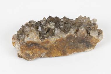 The Beechworth Burke Museum
Geological specimen - Smoky quartz crystals, unknown
... Burke Museum Beechworth microcrystalline quartz quartz mining ...Quartz is an extremely common mineral to find across the world. Quartz can have two forms; Microcrystalline quartz or Crystalline quartz. Microcrystalline quartz is a fine grain quartz where crystalline quartz is often a large crystal. This specimen is a crystalline quartz. Made of silicon oxide, this specimen is called smokey quartz crystals because of its brownish colour. However, the colour of quartz can vary. In addition, quartz are formed in deep-seated igneous rocks and crystallized through hot aqueous solutions. This type of crystal can be found all over Australia, including Beechworth in Victoria. Other places quartz can be found is the Ashburton River area in Western Australia, Marlborough in Queensland, the Lune River area in Tasmania and Kingsgate in New South Wales. This specimen is significant because it is common to find this kind of mineral. While the location of where this specimen was originally from is unknown, it highlights the many places in Australia where quartz is found. It demonstrates that quartz makes up a large portion of Australia's geology. In addition, quartz itself can vary in its colour and shape. This specimen represents one of these variations. That being smoky quartz crystals. This specimen is part of a larger collection of geological and mineral specimens collected from around Australia (and some parts of the world) and donated to the Burke Museum between 1868-1880. A large percentage of these specimens were collected in Victoria as part of the Geological Survey of Victoria that begun in 1852 (in response to the Gold Rush) to study and map the geology of Victoria. Collecting geological specimens was an important part of mapping and understanding the scientific makeup of the earth. Many of these specimens were sent to research and collecting organisations across Australia, including the Burke Museum, to educate and encourage further study.A large hand-sized quartz mineral with shades of brown and gray throughout.Smoky quartz / crystals /locality/ unknown / (needs a wash) /BBgeological specimen, geology, geology collection, burke museum, beechworth, microcrystalline, quartz, quartz mining, quartz reefs beechworth, smokey quartz crystals, crystals, crystalline, silicon oxide, brown, colour, igneous rocks, magma, ashburton river, western australia, marlborough, queensland, lune river, tasmania, kingsgate, new south wales, nsw -
 The Beechworth Burke Museum
Photograph, Unknown
The A1 Gold Mine is located north of Woods Point, near Jamieson, in the Upper Goulburn region of Victoria. Gold was discovered at the A1 site in 1861 and mining operations began in 1864. The A1 Mine Settlement refers to a small township known variously as Castle Reef, Castle Point, and Raspberry Creek, which developed in the 1860s around mining industry centred on a crushing machine that worked the three gold reefs in the area. Historically, the name "A1"referred to the high quality of gold found in the quartz reefs at depths of at least two thousand feet. Along with the Morning Star mine at Woods Point, the A1 gold mine produced almost sixty percent of Victoria's gold output in the 1950s to 1970s and continued operating until 1992 when it went into administration. Operations at the site were revived in 2016 and the A1 Mine is now considered one of Victoria's premier gold mines. The A1 mine is part of the extensive and prospective Lachlan Fold Belt, a north-west trending belt of tightly folded Early Devonian sedimentary rocks extending from New South Wales to Victoria. Mineralisation is hosted within or immediately adjacent to diorite dykes. Contemporary development of the 'Queens Lode' at the A1 mine signals a move from high-grade, narrow vein airleg mining into larger scale, mechanical mining designed to increase ore production volume. This original, undated photograph of the A1 Mine appears to depict an area or phase of disuse or abandonment. The aged and humble appearance of the cottage suggests association with the historical A1 Mine Settlement, therefore the image may have been taken prior to the 1950s-1970s revival period in which the A1 mine is known to have produced high gold yields. The photograph contributes to our understanding of the A1 Gold Mine's impact on the landscape and the social, environmental impacts of mining on communities and may be compared with others in the Burke Museum's extensive collection of mining photographs to deepen our understanding of mining in the Jamieson area.Black and white rectangular photograph printed on photographic paperReverse: 5577 / A1 Mine / Near Jamieson / Vic. /burke museum, beechworth museum, beechworth, gold fields, gold rush, victorian gold rush, mining tunnels, gold ming history, colonial australia, australian gold rushes, mining technology, beechworth historic district, indigo gold trail, indigo shire, upper goulburn shire, jamieson, woods point-walhalla goldfield, a1 gold mine, victorian high country, modern mining methods, orogenic gold province, gold mineralisation, devonian, dykes -
 The Beechworth Burke Museum
Photograph - Photograph - Reproduction, Unknown
This image is a reproduction of an 1899 original depicting the 'Williams Good Luck Mine' on the Mopoke Reef (also called 'Morepork Gully') in the Dingle Ranges, approximately three miles from Beechworth. The foreground of the image is littered with piles of smashed rock and detritus, known as ‘mullock’, beside a reinforced mine shaft, a vertical access passageway allowing miners to enter the mine and haul ore out using lifting technology such as a poppet heads, whims or windlasses. A group of miners and a dog appear close to an open-sided miner’s hut. Following the discovery of gold at Beechworth in 1852, rushes quickly followed at surrounding creeks and gullies in the district. In the late nineteenth and early twentieth centuries, small syndicates of miners continued to work old or abandoned quartz reefs, often persisting without the assistance of heavy machinery to remove the large amounts of rock, in order to obtain yields at ever greater depths. The group of miners in this photograph are Mr. Roger Williams and Sons, who revived operations at the ‘Old Good Luck’ mine on the Mopoke Reef in the Dingle Range near Beechworth around 1892, working the site for more than two decades. An emigrant from Cornwall with experience in the tin mining industry, 19 year old Roger Williams senior sailed to New Zealand in 1840, then to Australia where he spent time in the Bendigo Gold Fields before settling in Beechworth in the early 1860s. Mr Williams senior worked on various mining activities in the district, including the Rocky Mountain Tunnel project. Conversant with the character of gold-bearing reefs in the area, the syndicate dug an eight hundred foot tunnel, digging down as far down as two hundred feet with little capital save their labour, to connect and provide better working access to the mass of reefs and veins in the vicinity. Progress was hampered by poor air quality charged with fumes from dynamite and large quantities of rock had to be crushed to obtain payable yields. The Victorian Goldfields are filled with ruins and remnants of the area's rich mining history, ranging from small alluvial diggings to the remains of huge mining companies. Site names often changed several times throughout the nineteenth and twentieth centuries. Some sites were abandoned and forgotten, others were worked continuously over many decades. The names of mines were often repeated at different locations throughout the Victorian Goldfields. For example, there is a Mopoke Gully heritage mine near Fryers Creek, Victoria. 'Mopoke' is a common onomatopoeic name for Morepork and Australian Boobook owls. This image has historical, social and research significance for patterns of emigration during of the Victorian Gold Rush, and the historical, social and environmental impacts of mining at Beechworth at the turn of the nineteenth and twentieth centuries. As gold became scarce and government support and large company investment waned, poor hard-working miners laboured intensively to make a living through periods of high unemployment. This image can be compared and studied alongside other historical mining photographs and objects in the Burke Museum Collection. It has potential to improve our understanding of miners working conditions and the shifting character of mining in the Beechworth district. Black and white rectangular reproduction photograph printed on matte photographic paper.Obverse: Williams Good Luck Mine Beechworth / Roger! / Reverse: 6858 / burke museum, beechworth museum, beechworth, gold fields, gold rush, victorian gold rush, gold ming history, colonial australia, australian gold rushes, mining technology, beechworth historic district, indigo gold trail, migration, indigo shire, good luck gold mine, victorian goldfields, mining syndicates, gold fever, quartz-mining, small-scale mining, old good luck mine, mopoke gully, quartz reefs beechworth -
 Federation University Historical Collection
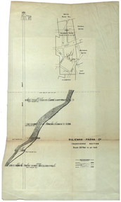
Plan, Sulieman Pasha Co Plan Transverse Section
The Sulieman Pasha is possibly named after the most important Sultan of the Ottoman Empire, Suleiman One, or Suleiman the Magnificent, when the Ottoman Empire was at its peak. Or potentially a number of Ottoman governors, statesmen and military commanders with the same name after, however the spelling is slightly different to the mine name. No Turkish connection was found relating to the formation of the company, and remains unconfirmed. The mine operated from two shafts; No. 1 near the corner of Humffray and Mair streets, and also near where the Welcome Nugget (2217 ounces) was found years earlier; and the controversial No. 2 shaft several blocks south bordering the northern side of the main highway through Ballarat. The company produced 62 666 ounces of gold, the twelfth highest quartz reef gold production for any mine on the Ballarat goldfield. Some crushing figure examples are January-June 1881: 3674 tonnes 1085 ounces; January-June 1885: 2949 tonnes 1281 ounces; July-December 1885: 4459 tonnes 1119 ounces; January-June 1887: 1869 tonnes 730 ounces; July-December 1892: 1450 tonnes 771 ounces; July-December 1896: 4365 tonnes 1372 ounces. Like many mines in the area, gold grades were low. John Watson was noted as mine manager in the 1880s, and John Williams 1890s. The company was re-organised twice increasing the number of shares from 4000 to 24 000, and increasing the capital available. The Sulieman Pasha Company was formed in 1878. David Fitzpatrick was given the honour of turning the first sod of both the No.1 and later No. 2 shafts. The first dividend was given to shareholders in July 1881. The company obtained a prospecting vote (government grant) to start, and was very proud to be the first Victorian gold mining company to pay the funds back to the government. The event was marked by a lavish banquet laid out for ministers and government officials by the company. Leases were purchased to the south in 1885 to the Llanberris Mine boundary, after poor results began accumulating from the small No. 1 shaft. To take advantage of this new land the company planned to sink a second shaft. Initially this was to take place on government land, but the uproar from nearby residents caused the company to purchase land along the Main Road (now Western Highway), and the old Yarrowee Hotel which had occupied the site since the alluvial digger days of the 1850's was demolished. The area had since those days become heavily occupied with a number of shops, houses, a post office, church and two schools in the immediate area. The thought of an underground mine next door drew considerable opposition. The company (before the days of public relations departments) wrote 'most people would have thought that progress as vital as mining would be supported by tradesmen whose business rely on the mining industry. It seems when it comes to mining they are bereft of their senses, and considering the low ebb of mining in Ballarat East, the action of our opponents are unaccountable. (Sarcastically) There are certain engineering difficulties in moving the quartz reefs to a new location, but if we could to appease our opponents we would'. The company also wanted to take over 4 acres of the St Paul's school oval for machinery, but accused the St Paul's Church of wanting extortionate amounts of money upfront, and on a yearly basis for the privilege. It stated the church could not be opposed to mining when several years earlier it had formed its own company to mine the land, only for shareholders to lose their money. In 1886, the company approached the Minister for Mines, and attended heated public meetings on the matter. The local residents, shop owners, and church submitted a 60 person petition to the local council and government authorities. They stated the shaft contravened the mining statutes, which stating no mining could take place within 150 yards of a public building or church. A speech by a resident stated 'mining always comes with glorious pictures of the great benefits which would accrue all parties concerned if their request is granted, but if property is destroyed or depreciated in value, no-one then comes forward and compensates them'. The No. 2 shaft was approved including taking over part of the school oval. In 1888, workers at the company's No. 2 shaft went on strike to try and bring their wages in line with other mines in the district (the No. 1 shaft was operated by tributers). William Madden (26) was killed from a fall of earth underground the same year, while a year later his father John Madden (70) was similarly killed in the Madame Berry Mine elsewhere in the district. In 1897 as the amount of gold being found fell away, it came to light part of the deal to purchase the Yarrowee Hotel site was a 5% royalty on gold found. Shareholders could not understand why they were paying a royalty to the former owners of the property. The mine closed in 1898 due to a lack of gold. In 1902 a boy (age unknown) called Charles Lee was killed from a fractured skull while working to dismantle the Sulieman Pasha plant. The fuss over the No. 2 shaft had a sequel. On the company winding up, the land was purchased by J.S. Trethowan who built a house next to the shaft. In 1907, the shaft caved-in creating a sinkhole immediately at the back of the house. A Mr Chamberlain heard a deep rumbling sound at 5am, and looked out the window to see his fowl house and thirteen chickens disappear down an expanding hole. He then went back to bed, and called the police later in the day. The shaft was 1050 feet deep, and the hole at the surface that developed was 20 feet by 17 feet across, and 20 feet depth. In 1930 it is reported a syndicate had been formed to clean out the old shaft, and re-open the mine. It is assumed this was the No. 1 shaft but no more was found. (https://www.mindat.org/loc-304239.html, accessed 07/08/2019) A transverse section plan of the Sulieman Pasha Mine.sulieman pasha company, plan, mining, united black hill mine, victoria united mine, victoria street, britannia united mine, last chance mine, llanberris mine, ottoman empire, john watson, john williams, david fitzpatrick -
 Federation University Historical Collection
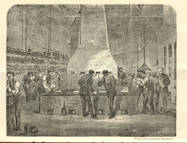
Booklet, The School of Mines Ballarat: A Statement of the Objects and Present Resources of the School, 1873
The Ballarat School of Mines was the first School of Mines in Australia and was established in 1870. 22 page booklet titles 'The Ballarat School of Mines: A Statement of the Objects and Resources of the School.' The book has a number of illustrations including the interior of the Ballarat School of Mines Laboratory, and the former Ballarat Circuit Court House. It includes a statement of the formation, progress, and present position of the School of Mines, Ballaarat. The image of the Ballarat School Mines Assay Room shows assay furnaces, crucibles, chimney, and teacher Joseph Flude on the far right. This room is now is a building known as the 'Old Chemistry Building'. Plan and elevation of the new Metallurgical Laboratory and Proposed Chemical Laboratory is depicted.On front cover "Recorded in M-A" "1873"ballarat school of mines, assay, courthouse, joseph flude, crucible, furnace, flude, warrington rogers, brough smyth, harrie wood, wood, james bickett, bickett, redmond barry, somerville learmonth, metallurgy, chemistry, laboratory, examinations, mining engineer, assayer, inorganic chemistry, underground managers, captains of shift, engieners, enginedrivers, louis balhausen, james campbell, l.s. christie, j.j. casey, alexander dempster, g. higinbotham, james martin, alexander millan, malcolm morrison, band of hope and albion, city of ballarat mining company, city of canterbury gold mining company, egerton mining company, el dorado gold mining company, golden reef gold mining company, happy valley company, hope quartz mining company, long tunnel gold mining company walhalla, hopewell quartz mining company, imperial quartz mining company, student numbers, fees, magdala quartz mining company stawell, mariners and sloane's quartz mining company, new north clunes company, park company, temperence quartz company, tookey quartz company new zealand, walhalla gold mining company, matthew seal, harrie woodmuseum, duke of cornwall claim, john lynch, robert m. sergeant, engineers, f.w. niven, william henry barnard, ballarat school of mines museum, museum, ballarat school of mines library, donations of specimens, mining -
 Federation University Historical Collection
Map, Ballaarat Gold Field, 1861
A party of surveyors camped by Yuille's Swamp (later Lake Wendouree) and surveyed the countryside for a map to be produced by the Geological Survey of Victoria. In November 2004 the Central Highlands Regional Library presented a special edition of 200 copies of the 1861 map reproduced from a copy in their collection. Original 1861 map of Ballarat showing streets and leads. Blue dots indicate gold leads, and red lines indicate auriferous quartz reef and outcrops of quartz veins."Compiled & Drawn from the Survey of Mining Surveyors Davidson, Fitzpatrick and Cowan & the Plans in the Surveyor General's Office by J. Brahe, 21st October 1861. R. Brough Smyth, Secretary for Mines. The Honourable J.B. Humffray, M.L.A. Commr of Mines.”ballarat, map, ballarat east, lake wendouree, survey, mines, robert davidson, ballarat gold field 1861, yuille's swamp, wendouree swamp, little bendigo diggings, gold leads, old post office hill, specimen hill, bakery hill, black hill, dead horse creek, brown hill, pennyweight hill, clayton hill, soldiers hill, golden point, gum tree flat, white flat, poverty hill, chinese village, robert brough smyth, ballarat map 1861, ballaarat vineyard, dead horse gully, deadhorse creek, invermay, black hill flat, gaelic church, police reserve, magpie range, dalton's flat, caadian lead, rifle butts, powder magazine, bathing house, government camp, gold office, chinese, llanberrris, victoria theatre, charlie napier hotel, united states hotel, grape's hoel, clayton's hill, cattleyard hill, free trade hotel, esmond lead, bakery hill, black hill lead, juvenile reformatory, ballarat orphanage, lady barkly lead, triffet's slaughter yard, little bendigo, melbourne road -
 Federation University Historical Collection
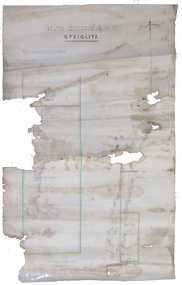
Plan, South Dividend Quartz Mining Company Plan
A hand drawn and coloured plan showing the position of the following gold mines in Steiglitz - South Dividend Company, the Marquis of Lorne Company, New Year's Reef, Malekoff Company and the Brazilian Reef.steiglitz, south dividend company, marquis of lorne company, new year's reef, malekoff company, brazilian reef, t. woolgrove -
 Federation University Historical Collection
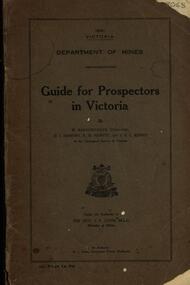
Book, Guide for Prospectors in Victoria, 1931
The handbook was intended for those with little experience who wanted to prospect of fossick.Grey soft covered book of 90 pages. Includes fold out map of a portion of Victoria showing auriferous areas and mineral localities. Also show Counties of Victoria and localities of minerals such as tin, antimony, copper, silver lead, Malybdenite, tungsten ores, manganese, platinum, osmiridium and iron. Chapter heading s include: working alluvial deposits, equipment, geology of Victoria, gold deposits, quartz reefs, indicators, economic minerals, assistance to prospectors, Miners' Right, mining bye-law, mining leases, forest regulations and glossary. Descriptions are given of a god dish, puddling tub, cradle, puddling machine, ground sluicing, boring, windlass, whim, hand dollying, sweeping, California pump, and wing dam.mining, baragwanath, gold, prospector, geology, quartz reefs, alluvial deposits, indicators, victorian goldfields, miners rights, mining leases, forest regulations, sluicing, sluice box, puddling machine, miner's cradle, whim, whip, california pump, gold nuggets, saddle reef, ballarat indicators, state batteries -
Marysville & District Historical Society
Document (item) - Gold Mine Prospectus, H.D. McKie, Prospectus of the New Golden Bower & Star Gold M.Co, 1896
A copy of the Prospectus of the New Golden Bower & Star Gold M.Co. near Marysville in Victoria.A copy of the Prospectus of the New Golden Bower & Star Gold M.Co. near Marysville in Victoria. The Golden Bower gold mine was a quartz reef mine. William Edward Chester discovered the Golden Secret gold vein which became part of the Golden Bower Mine at Chesterville near Donovans Creek on the Cumberland goldfield which he mined with George Locke until the late 1930s. new golden bower & star gold m.co., donovan's creek, nuggety gully creek, yarra track, marysville, victoria, share prospectus, upper yarra track, wood's point, victoria mount morgan gold mining co., british mount morgan mine, mr white, reefton turnoff, santa claus reef, bear's creek, mr r ely, bear's creek reef, big river, mr feely, new star reef, golden bower reef, a1 mining co, mr r m lee, locke's no.1 extended gold mining company, mr q dick -
Marysville & District Historical Society
Document (item) - Gold Mine Prospectus, Messrs Bruce & Robinson, Prospectus-Chester & Locke's Golden Secret Gold Mining Company, 1899
A copy of the prospectus for the Chester & Locke's Golden Secret Mining Company near Marysville in Victoria.A copy of the prospectus for the Chester & Locke's Golden Secret Mining Company near Marysville in Victoria. The Golden Bower gold mine was a quartz reef mine. William Edward Chester discovered the Golden Secret gold vein which became part of the Golden Bower Mine at Chesterville near Donovans Creek on the Cumberland goldfield which he mined with George Locke until the late 1930s. FOR PRIVATE CIRCULATIONshare prospectus, chester & locke's golden secret mining company, marysville, victoria, yarra track, upper yarra district, david newell, j.g. aikman, w.j. mountain, andrew barrie, gold mining, messrs w.p. jones and co., william chester, george locke, chesterville -
Federation University Historical Collection
Book, D.C. Davies et al, Metalliferous Minerals and Mining, 1892
Brown hard covered, illustrated book of 518 pages. It includes a bookplate of the Ballarat Ironworkers' and Polytechnical Association Library Rules. The book was bequethed to the Ironworkers' Association by the late James Oddie.mining, minerals, quartz, nova scotia, california, germany, ural mountains, gold deposits, virginia, new england, new brunswick, brazil, australia, new south wales, mount morgan, new zealand, africa, statistics, india, phillipines, aruba island, silver, russia, nevada, ruby hill, nevada, utah, emma mine, nevada, colarado, red mountain district, colorado, yankee girl mine, arizona, mexico, peru, bolivia, chili\copper, south africa, italy, austria, norway, swedan, france, cornwall, dolcoath mine, sandstone, parys mines of anglesea, carnarvonshire, cardiganshire, wicklow, ireland, mississippi valley, wisconsin, lake superior, wyoming, cuba, jamaica, venezuela, south australia, york peninsula, flinders ranges, japan, tin, banca, malaysia, bohemia, saxony, sweden, spain, cligga point, rin lodes of cornwall, andalusia, belgium, shropshire, isle of man, durham, westmoreland, limestone, flintshire, dengigshire, canada, lead, zinc, siberia, hungary, silesia, sardinia, algeria, ireland, new jersey, iron, lancashire, missouri, michigan, superstitions, equipment, cages, stopes, winzes, timbering, ventilation, fans, drilling, boring, dynamite, electricity, blasting, horse whims, water wheels, boilers, petterson's elephant ore stamp, stamper battery, jogs, linkenbach table, panning, cradle, quartz mining, hydraulic mining, alluvia; mining, altai mountains, north wales, neugluck mine, freiberg, christbescherung mine, drei prinzen lode, miask, woodville, virginia, gongo soco, brazil, sierra nevada, california, st john del rey mine, brazil, leydenberg gold field, south africa, banket reefs, transvaal, kongsberg, norway, santa rosa mine, peru, huelva, spain, dolcoath mine, cornwall, parys mine, anglesea, waterbury copper mine, lake superior, copiapo, chilli, altenberg, saxony, whea; uny, cornwall, wast wheel mine. redruth, cornwall, cligga point, cornwall, old hewas mine, cornwall, hartz, germany, snailbeach mine, shropshire, llangynog, north wales, van mine, mongomeryshire -
Federation University Historical Collection
Letter, Inward Correspondence to the Ballarat School of Mines, 1910, 08/1910
Inward Correspondence to the Ballarat School of Mines, August 1910letterhead, education department, gordon, c. brennan, l. eddy, state forests commission, edwin feild, royal victorian institute of architects, the steel company of australia, james martyn, clarke & co, ludwig alberti, scarsdale, thomas m. jude, justinian oxenham, clara davidson, robert davidson, j. roberts, h.b. silberberg & co, l. gilbert, macquarie steam brick yards, james dewar, r.j. flowerday, staffirdshire reef, john wilesmouth, bank of new south wales, victoria silicate brick company ltd, t.s. huggins, george f. roughhead, federal store, legislative assembly, andrew mckissock, city of ballarat, r. e. williams, ballarat school of mines battery assistant, edgar c. hurdsfield, bairnsdale school of mines, w. kingston, gordon technical college, h.l. langdon & co., felton grimwade, f.f. brunn, bendigo school of mines, gold buyers bill, chaffey salmon & dunne, h.j. thwaites, cobar, henry leahy, h. blyth, s. radcliff, archie buchanan, launceston, fairthorne and sons, sloanes and scotchmans united quartz mining company, james eton, albert bradford, 109 lyons st north -
 The Beechworth Burke Museum
Postcard, 1920
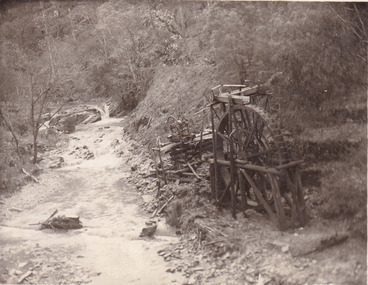
... . beechworth mining gold mining quartz mining wallaby reef mine mine ...This postcard depicts the set-up of an abandoned gold mine. This includes a water wheel and other mining implements next to a creek. The postcard inscription indicates that this image is of the remains of the Wallaby Reef battery and water wheel. Wallaby Reef was discovered in 1864, and a prospecting claim established a four head battery and water wheel. Quartz was mined there, with gold also discovered at this location at a later date. By 1878 the mine was no longer resulting in rich deposits, this resulted in the miners moving their search for gold closer to the river where they were able to access more gold. This was in approximately 1879. In 1882 a rich deposit was found. In 1908 the battery was closed, and the mine finished. This photo was taken in 1920 and shows the deterioration of the site since its closure. Gold mining was crucial to the development of the Beechworth area. It has strong research and historical value because the clarity of the photo shows all the minute details of the mining equipment. The text on the back also indicates the mine is the Wallaby Mine, which was used for 45 years to find gold and quartz. Therefore, due to the location being quickly abandoned, this site is a rich location for historical study on gold mining during the 1900s. It can provide important information on the types of tools utilised and the impact of the mining on the environment.Black and white postcard photograph on card.8169 Be / Also near Wallaby Reef Workings / Relics of Rechabite Reef (locality) workings. / Shaft in bed of creek. Wheel used to drive sheadd (?) / stamp battery too I believe near B'worth 1920?beechworth, mining, gold mining, quartz mining, wallaby reef mine, mine battery head -
Stawell Historical Society Inc
The Australian Sketcher Article, Stawell and the Pleasant Creek reefs July 12 1873, July 12 1873
Article printed after legislation arising out of 'Jumped Claims' back in history of Pleasant Creek - alluvial and quartz mining Currant mining operationsPhotocopy of article with lithographs and plan of Stawell -
 Stawell Historical Society Inc
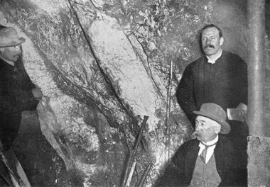
Photograph, "Amalgamated Scotchman's" Underground Mine with the face at the 1100 ft level & 3 miners inspecting the Quartz Reef
Three men inspecting Quartz reef in Amalgamated Scotchman's Underground Mine 1895. Showing the face of the 1.100ft level. Illustrated the Magdala Lode appearance.stawell mining